
File:People's Republic of China (orthographic projection).svg

Size of this PNG preview of this SVG file: pikseelii 541 × 541. Kabiraa furmaatawwan: pikseelii 240 × 240 | pikseelii 480 × 480 | pikseelii 768 × 768 | pikseelii 1,024 × 1,024 | pikseelii 2,048 × 2,048.
Faayila abbaa (SVG file, nominally 541 × 541 pixels, file size: 260 KB)
Guduunfaa
| Ibsa |
Italiano: La Repubblica Popolare Cinese (in verde) e il territorio da essa dichiarato (in verde chiaro).
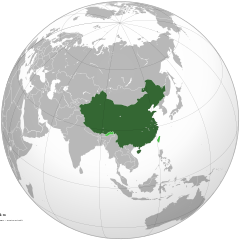
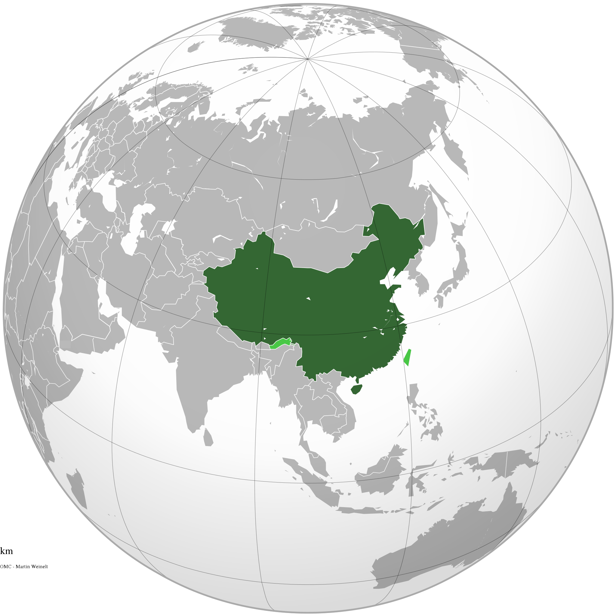
English: The People's Republic of China (green) and its claimed territory (lighter green).
Русский: Китайская Народная Республика (зелёный).
Українська: Територія Китаю позначена зеленим. Територія, на яку претендує Китай, але не контролює її, позначена світло-зеленим.
中文(简体):中华人民共和国(深绿色)及其认为拥有主权的地区(浅绿色)。
中文(繁體):中華人民共和國(深綠色)及其自認為擁有主權的地區(淺綠色)。 |
||||
| Guyyaa | |||||
| Lakkaddaa |
Hojii ofii (Original text: Own work)
|
||||
| Barreessaa | Ssolbergj | ||||
| Other versions |
.svg)
|
||||
| SVG genesis |
.jpg)
.svg)
.svg)
.svg)
.svg)
.svg)
.svg)
.svg)
.svg)
.svg)
.svg)
.svg)
.svg)
.svg)
.svg)
.svg)
.svg)
.svg)
.svg)
.svg)
.svg)
.svg)
.svg)
.svg)
.svg)
.svg)
.svg)
.svg)
.svg)
.svg)
.svg)
.svg)
.svg)
.svg)
.svg)
.svg)
.svg)
.svg)
.svg)
.svg)
.svg)
.svg)
.svg)
.svg)
.svg)
.svg)
.svg)
.svg)
.svg)
.svg)
.svg)
.svg)
.svg)
.svg)
.svg)
.svg)
.svg)
.svg)
.svg)
.svg)
.svg)
.svg)
.svg)
.svg)
.svg)
.svg)
.svg)
.svg)
.svg)
.svg)
.svg)
.svg)
.svg)
.svg)

.svg)

.svg)

.svg)
.svg)
.svg)
.svg)
.svg)
.svg)
.svg)


.svg)
.svg)
.svg)
.svg)
.svg)
.svg)
.svg)

.svg)
.svg)
.svg)
.svg)
.svg)
.svg)
.svg)
.svg)
.svg)

.svg)
.svg)
.svg)
.svg)
.svg)
.svg)
.svg)
_without_national_boundaries.svg)
.svg)
.svg)
.svg)
.svg)
.svg)
.svg)

.svg)
.svg)
.png)
.svg)
.svg)
.svg)
.svg)

.svg)
.svg)
.svg)
.svg)
.svg)
.svg)
.svg)
.svg)
.svg)
.svg)
.svg)

.svg)
.svg)
.svg)
.svg)
.svg)
.svg)
.svg)
.svg)
.svg)

.svg)
.svg)

.svg)
.svg)
.svg)
.svg)
.svg)
.svg)
.svg)
.svg)
.svg)
.svg)
.svg)
.svg)
.svg)
.svg)
.svg)
.svg)
.svg)
.svg)
.svg)
.svg)
.svg)
.svg)
.svg)
.svg)
.svg)
.svg)
.svg)
_-_Crimea_disputed.svg)
.svg)
.svg)
.svg)
.svg)
.svg)
.svg)
.svg)
.svg)
.svg)
.svg)
.svg)
_political.svg)
.svg)
.svg)
.svg)
.svg)
_-_Crimea_disputed_-_no_borders.svg)
.svg)
.svg)
.svg)
.svg)
.svg)
.svg)
.svg)
.svg)
.svg)
.svg)
.svg)

.svg)
.svg)
.svg)

.png)
.svg)
.svg)
.svg)
.svg)
.svg)
.svg)
.svg)
.svg)
.svg)
.svg)
.svg)
.svg)
.svg)
.svg)
.svg)
.svg)
.svg)
.svg)
.svg)
.svg)
.svg)
.svg)
.svg)
.svg)
.svg)
.svg)
.svg)
.svg)
.svg)
.svg)
.svg)
.svg)
.svg)
.svg)
.png)
.svg)
.svg)
.svg)
_(orthographic_projection).png)
.svg)
.svg)
.svg)
Eeyyamsiisuu
I, the copyright holder of this work, hereby publish it under the following licenses:

|
Permission is granted to copy, distribute and/or modify this document under the terms of the GNU Free Documentation License, Version 1.2 or any later version published by the Free Software Foundation; with no Invariant Sections, no Front-Cover Texts, and no Back-Cover Texts. A copy of the license is included in the section entitled GNU Free Documentation License. |
This file is licensed under the Creative Commons Attribution-Share Alike 4.0 International, 3.0 Unported, 2.5 Generic, 2.0 Generic and 1.0 Generic license.
- Ati bilisa:
- qooduuf – hojicha garagalchuuf, faffacaasuu fi daddabarsuuf
- walimakuuf – hojicha madaqsuuf
- Haalota armaan gadii jalatti:
- amala – You must give appropriate credit, provide a link to the license, and indicate if changes were made. You may do so in any reasonable manner, but not in any way that suggests the licensor endorses you or your use.
- wal waliif qoodamu – If you remix, transform, or build upon the material, you must distribute your contributions under the same or compatible license as the original.
Eeyyama filmaata keeti filuu dandeessa.
Seenaa faayilaa
Faayilicha sa'aa san akka itti mul'atetti ilaaluuf guyyaa/yeroo cuqaasi.
.svg&dir=prev)
.svg&offset=20111111220409)
.svg&offset=&limit=20)
.svg&offset=&limit=50)
.svg&offset=&limit=100)
.svg&offset=&limit=250)
.svg&offset=&limit=500)
| Guyyaa/Sa'aa | Qeensa abgudduu | Kallattiiwwan | Fayyadamaa | Yaada | |
|---|---|---|---|---|---|
| amma | 15:16, 29 Muddee 2019 | | 541 × 541 (260 KB) | Goran tek-en | Added border for South Sudan as requested by Maphobbyist |
| 06:05, 25 Caamsaa 2014 |  | 541 × 541 (142 KB) | Chipmunkdavis | Rv removal of claimed territories | |
| 16:05, 23 Caamsaa 2014 |  | 541 × 541 (498 KB) | Lawson123 | Reverted to version as of 17:14, 15 March 2014 | |
| 19:13, 15 Bitootessa 2014 |  | 541 × 541 (142 KB) | Chipmunkdavis | Rv removal of claimed territories | |
| 17:14, 15 Bitootessa 2014 |  | 541 × 541 (498 KB) | Semidwarf | Reverted to version as of 20:49, 14 March 2014 | |
| 00:14, 15 Bitootessa 2014 |  | 541 × 541 (142 KB) | Chipmunkdavis | Rv removal of claimed territories | |
| 20:49, 14 Bitootessa 2014 |  | 541 × 541 (498 KB) | Semidwarf | Reverted to version as of 14:49, 9 April 2011 | |
| 20:48, 14 Bitootessa 2014 |  | 541 × 541 (498 KB) | Semidwarf | Reverted to version as of 14:49, 9 April 2011 | |
| 21:53, 12 Fulbaana 2012 |  | 541 × 541 (142 KB) | Palosirkka | Scrubbed with http://codedread.com/scour/ | |
| 22:04, 11 Sadaasa 2011 |  | 541 × 541 (481 KB) | Gucong | According to http://en.wikipedia.org/wiki/Wikipedia:WikiProject_Maps/Conventions/Orthographic_maps , claimed areas shall be marked as light green |
Fayyadamiinsa faayilaa
Kutaan itti anuu "file"ii kanan walitti qabatta:
Fayyadamiinsa faayila guutu addunyaa
Wikileen biroo kan armaan gadi jiran fayila kana fayyadamu:
- Fayyadamiinsa af.wikipedia.org irratti
- Fayyadamiinsa ami.wikipedia.org irratti
- Fayyadamiinsa arc.wikipedia.org irratti
- Fayyadamiinsa ar.wikipedia.org irratti
- Fayyadamiinsa as.wikipedia.org irratti
- Fayyadamiinsa av.wikipedia.org irratti
- Fayyadamiinsa azb.wikipedia.org irratti
- Fayyadamiinsa az.wikipedia.org irratti
- Fayyadamiinsa az.wiktionary.org irratti
- Fayyadamiinsa ban.wikipedia.org irratti
- Fayyadamiinsa ba.wikipedia.org irratti
- Fayyadamiinsa bcl.wikipedia.org irratti
- Fayyadamiinsa beta.wikiversity.org irratti
- Fayyadamiinsa be.wikipedia.org irratti
- Fayyadamiinsa bh.wikipedia.org irratti
- Fayyadamiinsa bn.wikipedia.org irratti
- Fayyadamiinsa cdo.wikipedia.org irratti
- Fayyadamiinsa cs.wikipedia.org irratti
- Fayyadamiinsa cu.wikipedia.org irratti
- Fayyadamiinsa da.wikipedia.org irratti
- Fayyadamiinsa de.wiktionary.org irratti
- Fayyadamiinsa dty.wikipedia.org irratti
- Fayyadamiinsa dz.wikipedia.org irratti
- Fayyadamiinsa el.wikipedia.org irratti
- Fayyadamiinsa el.wikinews.org irratti
- Το Διεθνές Νομισματικό Ταμείο προειδοποεί τη Κίνα για το γουάν
- Πρότυπο:Κίνα
- Ατύχημα με 41 νεκρούς στη Κίνα
- Κίνα: Η στήριξη της Ελλάδας αποτελεί σημαντικό βήμα για την Ευρωζώνη
- Συνεχίζονται οι απεργίες των ταξί στη Κίνα
- Πενηντατέσσερις αμαξοστοιχίες ανακαλούνται στην Κίνα για λόγους ασφαλείας
- Η Coca-Cola θα επενδύσει 4 δισεκατομμύρια δολάρια στη Κίνα για τα επόμενα 3 έτη
- Διασώθηκαν 19 παγιδευμένοι ανθρακωρύχοι στη Κίνα
- Ήπια ενίσχυση της μεταποίησης στη Κίνα
- Δέκα ανθρακωρύχοι ανασύρθηκαν νεκροί από ορυχείο της Κίνας
- Ανακαλύφθηκε τάφος με 12 άλογα στη Κίνα
- Έντεκα άτομα σκοτώθηκαν σε ναυάγιο στη Κίνα
- Κίνα: Δεκάδες νεκροί και αγνοούμενοι ύστερα από ισχυρές βροχοπτώσεις
- Κρούσματα πολιομυελίτιδας στην Κίνα για πρώτη φορά από το 1999
- Στη Κίνα συνελήφθη άνδρας που βίαζε στο υπόγειο έξι γυναίκες για δύο χρόνια
- Σανγκάη: Εκατοντάδες τραυματίες σε σύγκρουση συρμών του μετρό
- Στην Κίνα ο Βλαντιμίρ Πούτιν
Mul'isa fayyadama duniyaalessa edaasaa harshama kanaa.
.svg)
.svg)