
File:Awashrivermap.png

Hammi agarsiisa yaalii: pikseelii 603 × 599. Kabiraa furmaatawwan: pikseelii 241 × 240 | pikseelii 483 × 480 | pikseelii 772 × 768 | pikseelii 1,203 × 1,196.
Faayila abbaa (1,203 × 1,196 pixels, file size: 1.21 MB, MIME type: image/png)
Guduunfaa
| Ibsa |
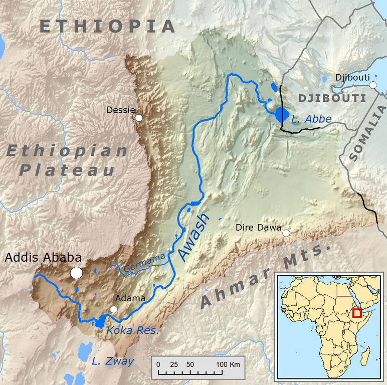
English: Map showing the Awash River drainage basin.
Français : Carte du bassin versant du fleuve Awash (bassin endoréique). |
| Guyyaa | |
| Lakkaddaa | Hojii ofii, Elevation data from SRTM, drainage basin from GTOPO [1], all other features from Vector Map. Rand McNally "New International Atlas" (1993) used as reference. |
| Barreessaa | Kmusser |
Eeyyamsiisuu
I, the copyright holder of this work, hereby publish it under the following license:
This file is licensed under the Creative Commons Attribution-Share Alike 3.0 Unported license.
- Ati bilisa:
- qooduuf – hojicha garagalchuuf, faffacaasuu fi daddabarsuuf
- walimakuuf – hojicha madaqsuuf
- Haalota armaan gadii jalatti:
- amala – You must give appropriate credit, provide a link to the license, and indicate if changes were made. You may do so in any reasonable manner, but not in any way that suggests the licensor endorses you or your use.
- wal waliif qoodamu – If you remix, transform, or build upon the material, you must distribute your contributions under the same or compatible license as the original.
Seenaa faayilaa
Faayilicha sa'aa san akka itti mul'atetti ilaaluuf guyyaa/yeroo cuqaasi.
| Guyyaa/Sa'aa | Qeensa abgudduu | Kallattiiwwan | Fayyadamaa | Yaada | |
|---|---|---|---|---|---|
| amma | 22:29, 1 Muddee 2018 | | 1,203 × 1,196 (1.21 MB) | Kmusser | Fix to basin boundary and zoom in |
| 18:15, 6 Haggaya 2010 |  | 1,002 × 1,000 (1.63 MB) | Kmusser | == Summary == {{Information |Description=Map showing the Awash River drainage basin. |Source={{own}}, Elevation data from SRTM, drainage basin from GTOPO [http://eros.usgs.gov/#/Find_Data/Products |
Fayyadamiinsa faayilaa
Fuulotni faayila kana fayyadaman hin jiru.
Fayyadamiinsa faayila guutu addunyaa
Wikileen biroo kan armaan gadi jiran fayila kana fayyadamu:
- Fayyadamiinsa af.wikipedia.org irratti
- Fayyadamiinsa am.wikipedia.org irratti
- Fayyadamiinsa ar.wikipedia.org irratti
- Fayyadamiinsa as.wikipedia.org irratti
- Fayyadamiinsa azb.wikipedia.org irratti
- Fayyadamiinsa be.wikipedia.org irratti
- Fayyadamiinsa bo.wikipedia.org irratti
- Fayyadamiinsa br.wikipedia.org irratti
- Fayyadamiinsa bs.wikipedia.org irratti
- Fayyadamiinsa cs.wikipedia.org irratti
- Fayyadamiinsa da.wikipedia.org irratti
- Fayyadamiinsa de.wikipedia.org irratti
- Fayyadamiinsa en.wikipedia.org irratti
- Fayyadamiinsa eo.wikipedia.org irratti
- Fayyadamiinsa es.wikipedia.org irratti
- Fayyadamiinsa eu.wikipedia.org irratti
- Fayyadamiinsa fi.wikipedia.org irratti
- Fayyadamiinsa fr.wikipedia.org irratti
- Fayyadamiinsa ha.wikipedia.org irratti
- Fayyadamiinsa he.wikipedia.org irratti
- Fayyadamiinsa hi.wikipedia.org irratti
- Fayyadamiinsa hu.wikipedia.org irratti
- Fayyadamiinsa ilo.wikipedia.org irratti
- Fayyadamiinsa it.wikipedia.org irratti
- Fayyadamiinsa ja.wikipedia.org irratti
- Fayyadamiinsa ko.wikipedia.org irratti
- Fayyadamiinsa la.wikipedia.org irratti
- Fayyadamiinsa lt.wikipedia.org irratti
- Fayyadamiinsa new.wikipedia.org irratti
- Fayyadamiinsa nl.wikipedia.org irratti
- Fayyadamiinsa no.wikipedia.org irratti
- Fayyadamiinsa pa.wikipedia.org irratti
- Fayyadamiinsa pl.wikipedia.org irratti
- Fayyadamiinsa pnb.wikipedia.org irratti
- Fayyadamiinsa ru.wikipedia.org irratti
- Fayyadamiinsa sh.wikipedia.org irratti
Mul'isa fayyadama duniyaalessa edaasaa harshama kanaa.